Cabarrus GIS maps enhanced with updated aerial imagery
Published on May 11, 2023
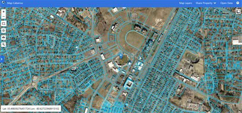
Cabarrus County recently added 2023 aerial imagery to Map Cabarrus, the Geographic Information System (GIS) website. The updated visuals enhance the accuracy of the maps and integrate with County departments, governmental jurisdictions, agencies and the public.
Flying at low altitudes with high-tech cameras, aerial imaging company EagleView photographed all of Cabarrus at high resolution. The images were stitched into a mosaic and uploaded to Map Cabarrus.
Map Cabarrus is useful for real estate agents and developers and is integral for County departments like Planning and Development, Permitting and Tax Administration. The service also allows the Sheriff’s Office to properly route 911 calls and validate locations when responding to calls.
“In these maps, you can find information on properties, townships, zoning, schools, services and more,” says Cabarrus County Chief Information Officer Todd Shanley.
EagleView is contracted to fly the entire county every two years, ensuring the everchanging landscape is accurately reflected on Map Cabarrus.
In the late 90s, Cabarrus became one of the first counties in the nation to offer GIS online. Historic imagery dating back to 1938 can be found in the dropdown under “Map Layers” on the main Map Cabarrus page.
Map Cabarrus is one the most visited pages of the County’s recently revamped and award-winning website, with nearly half a million visits in the last 12 months.
In addition to the new aerial images captured between January and February of 2023, Cabarrus County also offers a variety of other services to residents and businesses via the website, including:
- CLaRIS, a land records system that identifies all parcels and lists the taxable owner(s) of record
- Accela, a one-stop shop for all planning, reviews, zoning, permitting and inspection services
- myCabCo, a quick and easy way to pay property taxes online
Cabarrus’ Information Technology Services department monitors traffic and search terms on the website, adjusting the top selections based on the site’s biggest draws.
To access the new aerial imagery and all online County services, visit www.cabarruscounty.us.